
Thank you for supporting this site ❤️
Make a donation
Make a donation
Le Tevelave topographic map
Click on the map to display elevation.
Thank you for supporting this site ❤️
Make a donation
Make a donation
Le Tevelave
Situé à 900 mètres d'altitude, sur le versant sud-ouest de l'île, le village est adossé à la forêt et fait face à l'océan Indien en de superbes panoramas.
Thank you for supporting this site ❤️
Make a donation
Make a donation
About this map
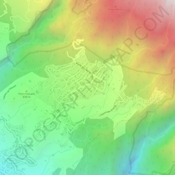
Name: Le Tevelave topographic map, elevation, terrain.
Average elevation: 890 m
Minimum elevation: 523 m
Maximum elevation: 1,348 m
Thank you for supporting this site ❤️
Make a donation
Make a donation