
Thank you for supporting this site ❤️
Make a donation
Make a donation
Vizianagaram topographic map
Click on the map to display elevation.
Thank you for supporting this site ❤️
Make a donation
Make a donation
Vizianagaram
Vizianagaram is located at 18°07′N 83°25′E / 18.12°N 83.42°E / 18.12; 83.42. It has an average elevation of 74 metres (242 feet). The Champavathi River flows near the city.
Thank you for supporting this site ❤️
Make a donation
Make a donation
About this map
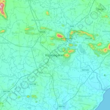
Name: Vizianagaram topographic map, elevation, terrain.
Average elevation: 57 m
Minimum elevation: 0 m
Maximum elevation: 655 m
Thank you for supporting this site ❤️
Make a donation
Make a donation