
Thank you for supporting this site ❤️
Make a donation
Make a donation
Metamora topographic map
Click on the map to display elevation.
Thank you for supporting this site ❤️
Make a donation
Make a donation
About this map
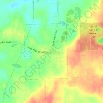
Name: Metamora topographic map, elevation, terrain.
Average elevation: 322 m
Minimum elevation: 293 m
Maximum elevation: 349 m
Thank you for supporting this site ❤️
Make a donation
Make a donation
Other topographic maps
Click on a map to view its topography, its elevation and its terrain.
Metamora-Hadley State Recreation Area
United States > Michigan > Lapeer County > Metamora
Average elevation: 298 m
Thank you for supporting this site ❤️
Make a donation
Make a donation