
Thank you for supporting this site ❤️
Make a donation
Make a donation
Lanín topographic map
Click on the map to display elevation.
Thank you for supporting this site ❤️
Make a donation
Make a donation
About this map
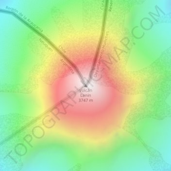
Name: Lanín topographic map, elevation, terrain.
Location: Lanín, Departamento Huiliches, Neuquén, Argentina (-39.63727 -71.50311 -39.63717 -71.50301)
Average elevation: 3,005 m
Minimum elevation: 2,465 m
Maximum elevation: 3,738 m
Thank you for supporting this site ❤️
Make a donation
Make a donation
Other topographic maps
Click on a map to view its topography, its elevation and its terrain.
Thank you for supporting this site ❤️
Make a donation
Make a donation
Villa Pehuenia
Villa Pehuenia sprawls over about 5 kilometres (3.1 mi) of the northern shore of Lake Aluminé, but is concentrated on two narrow peninsulas extending out into the lake. Rising near the village is the Batea Mahuida volcano which reaches a maximum elevation of 1,948 metres (6,391 ft) about 8 kilometres (5.0 mi)…
Average elevation: 1,240 m