
Pyhrn topographic map
Interactive map
Click on the map to display elevation.
About this map
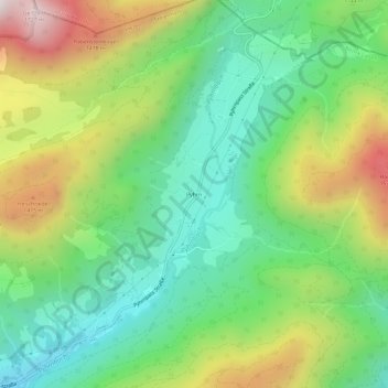
Name: Pyhrn topographic map, elevation, terrain.
Location: Pyhrn, Liezen, Bezirk Liezen, Steiermark, 8940, Österreich (47.57387 14.25929 47.61387 14.29929)
Average elevation: 1,067 m
Minimum elevation: 682 m
Maximum elevation: 1,738 m
Other topographic maps
Click on a map to view its topography, its elevation and its terrain.
Weißenbach
Österreich > Steiermark > Bezirk Liezen > Liezen
Weißenbach, Liezen, Bezirk Liezen, Steiermark, 8940, Österreich
Average elevation: 763 m