
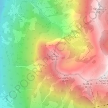
Rubihorn topographic map
Interactive map
Click on the map to display elevation.
About this map
Name: Rubihorn topographic map, elevation, terrain.
Average elevation: 1,467 m
Minimum elevation: 858 m
Maximum elevation: 2,034 m
Other topographic maps
Click on a map to view its topography, its elevation and its terrain.
Allgäuer Alpen
Deutschland > Bayern > Oberstdorf
Allgäuer Alpen, Bayern, Deutschland
Average elevation: 1,301 m
Nebelhorn
Deutschland > Bayern > Oberstdorf
Nebelhorn, Oberstdorf, Landkreis Oberallgäu, Bayern, Deutschland
Average elevation: 1,792 m
Schwand
Deutschland > Bayern > Oberstdorf > Schwand
Schwand, Oberstdorf, Landkreis Oberallgäu, Bayern, 87561, Deutschland
Average elevation: 1,201 m
Hoher Ifen
Deutschland > Bayern > Oberstdorf
Hoher Ifen, Oberstdorf, Landkreis Oberallgäu, Schwaben, Bayern, Deutschland
Average elevation: 1,826 m
Höfats Ostgipfel
Deutschland > Bayern > Oberstdorf
Höfats Ostgipfel, Oberstdorf, Landkreis Oberallgäu, Schwaben, Bayern, Deutschland
Average elevation: 1,595 m
Kleiner Wilder
Deutschland > Bayern > Oberstdorf
Kleiner Wilder, Oberstdorf, Landkreis Oberallgäu, Schwaben, Bayern, Deutschland
Average elevation: 1,839 m
Bockkarkopf
Deutschland > Bayern > Oberstdorf
Bockkarkopf, Oberstdorf, Landkreis Oberallgäu, Schwaben, Bayern, Deutschland
Average elevation: 2,150 m
Mädelegabel
Deutschland > Bayern > Oberstdorf
Mädelegabel, Oberstdorf, Landkreis Oberallgäu, Schwaben, Bayern, Deutschland
Average elevation: 2,093 m
Kleiner Seekopf
Deutschland > Bayern > Oberstdorf
Kleiner Seekopf, Oberstdorf, Landkreis Oberallgäu, Schwaben, Bayern, Deutschland
Average elevation: 1,711 m
Biberkopf
Deutschland > Bayern > Oberstdorf
Biberkopf, Oberstdorf, Landkreis Oberallgäu, Schwaben, Bayern, 6993, Deutschland
Average elevation: 1,956 m
Trettach
Deutschland > Bayern > Oberstdorf
Trettach, Oberstdorf, Landkreis Oberallgäu, Schwaben, Bayern, 87561, Deutschland
Average elevation: 996 m