
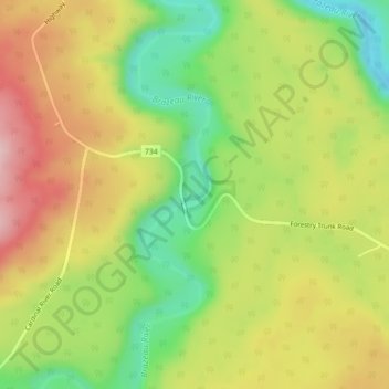
Brazeau River Provincial Recreation Area topographic map
Interactive map
Click on the map to display elevation.
About this map
Name: Brazeau River Provincial Recreation Area topographic map, elevation, terrain.
Average elevation: 1,325 m
Minimum elevation: 1,218 m
Maximum elevation: 1,433 m
Other topographic maps
Click on a map to view its topography, its elevation and its terrain.
Brule
Canada > Alberta > Yellowhead County
Brule, Yellowhead County, Alberta, Canada
Average elevation: 1,135 m
Rock Lake Provincial Park
Canada > Alberta > Yellowhead County
Rock Lake Provincial Park, Yellowhead County, Alberta, Canada
Average elevation: 1,612 m
Yates Natural Area
Canada > Alberta > Yellowhead County
Yates Natural Area, Township Road 534, Yellowhead County, Alberta, Canada
Average elevation: 880 m
Peers
Canada > Alberta > Yellowhead County
Peers, Yellowhead County, Alberta, Canada
Average elevation: 850 m
Fairfax Lake
Canada > Alberta > Yellowhead County
Fairfax Lake, Yellowhead County, Alberta, Canada
Average elevation: 1,347 m
Folding Mountain
Canada > Alberta > Yellowhead County
Folding Mountain, Yellowhead County, Alberta, Canada
Average elevation: 1,806 m
Robb
Canada > Alberta > Yellowhead County
Robb, Yellowhead County, Alberta, Canada
Average elevation: 1,142 m
Luscar
Canada > Alberta > Yellowhead County
Luscar, Yellowhead County, Alberta, Canada
Average elevation: 1,718 m