
Of topographic map
Interactive map
Click on the map to display elevation.
About this map
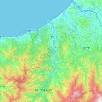
Name: Of topographic map, elevation, terrain.
Location: Of, Trabzon, Black Sea Region, 61830, Turkey (40.77508 40.18978 40.98833 40.47715)
Average elevation: 414 m
Minimum elevation: 0 m
Maximum elevation: 1,897 m
There are several stories about the origins of Of's name. Of was called Ofis in 1910 by Pontic Greek speaking inhabitants. According to another view it means "village" or "settlement" in the Laz language (Laz: ოფუტე/oput'e), as the old name of the town is mentioned as "Opiunte" on the Tabula Peutingeriana. By another version of events, the city got its name from a nearby river described by Arrian as Ophis, a Greek word for "snake". The Ophius stream - which snakes (zigzags) its way from around 3300 meters altitude in the Pontic Mountains towards the coastal town of Of - was renamed as "Solaklı" during the 1950s Turkification process which is a common policy in all of Turkey.
Other topographic maps
Click on a map to view its topography, its elevation and its terrain.
Ortahisar Mahallesi
Ortahisar Mahallesi, Ortahisar, Trabzon, Black Sea Region, Turkey
Average elevation: 72 m
Atapark
Turkey > Trabzon > Ortahisar > Gülbaharhatun Mahallesi
Atapark, Gülbaharhatun, Gülbaharhatun Mahallesi, Ortahisar, Trabzon, Black Sea Region, Turkey
Average elevation: 63 m