
Midland Township topographic map
Interactive map
Click on the map to display elevation.
About this map
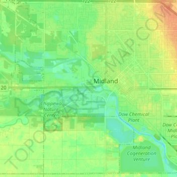
Name: Midland Township topographic map, elevation, terrain.
Location: Midland Township, Midland County, Michigan, United States (43.56854 -84.29072 43.65469 -84.16717)
Average elevation: 191 m
Minimum elevation: 178 m
Maximum elevation: 211 m
Other topographic maps
Click on a map to view its topography, its elevation and its terrain.
Coleman
United States > Michigan > Midland County
Coleman, Midland County, Michigan, United States
Average elevation: 231 m
Hope
United States > Michigan > Midland County
Hope, Hope Township, Midland County, Michigan, 48628, United States
Average elevation: 205 m
Warren Township
United States > Michigan > Midland County
Warren Township, Midland County, Michigan, 48618, United States
Average elevation: 223 m
Mills Township
United States > Michigan > Midland County
Mills Township, Midland County, Michigan, United States
Average elevation: 207 m
Midland
United States > Michigan > Midland County
Midland, Midland County, Michigan, United States
Average elevation: 194 m
Greendale Township
United States > Michigan > Midland County
Greendale Township, Midland County, Michigan, United States
Average elevation: 208 m