
Make a donation
Far Hills topographic map
Click on the map to display elevation.
Make a donation
About this map
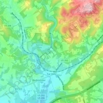
Name: Far Hills topographic map, elevation, terrain.
Location: Far Hills, Somerset County, New Jersey, 07931, United States (40.66720 -74.65122 40.72812 -74.59430)
Average elevation: 100 m
Minimum elevation: 33 m
Maximum elevation: 256 m
Make a donation
Other topographic maps
Click on a map to view its topography, its elevation and its terrain.
Basking Ridge
United States > New Jersey > Somerset County > Bernards Township
Average elevation: 98 m
Make a donation
Make a donation
Make a donation
Chimney Rock
United States > New Jersey > Somerset County > Bridgewater Township
Average elevation: 56 m
Make a donation
Make a donation
Woods Tavern
United States > New Jersey > Somerset County > Hillsborough Township
Average elevation: 28 m
Make a donation
North Branch Depot
United States > New Jersey > Somerset County > North Branch Depot
Average elevation: 38 m
Make a donation
Liberty Corner
United States > New Jersey > Somerset County > Bernards Township > Liberty Corner
Average elevation: 85 m
Make a donation
Green Knoll
United States > New Jersey > Somerset County > Bridgewater Township
Average elevation: 63 m