
Thank you for supporting this site ❤️
Make a donation
Make a donation
Mosson topographic map
Click on the map to display elevation.
Thank you for supporting this site ❤️
Make a donation
Make a donation
About this map
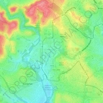
Name: Mosson topographic map, elevation, terrain.
Average elevation: 66 m
Minimum elevation: 29 m
Maximum elevation: 121 m
Thank you for supporting this site ❤️
Make a donation
Make a donation
Other topographic maps
Click on a map to view its topography, its elevation and its terrain.
Pessière (seuil) du barrage de l'ancien moulin de Lavalette
France > Occitanie > Hérault > Montpellier
Average elevation: 58 m
Thank you for supporting this site ❤️
Make a donation
Make a donation
Lycée général et technologique Joffre
France > Occitanie > Hérault > Montpellier
Average elevation: 30 m