
Thank you for supporting this site ❤️
Make a donation
Make a donation
Lac Rectangle topographic map
Click on the map to display elevation.
Thank you for supporting this site ❤️
Make a donation
Make a donation
About this map
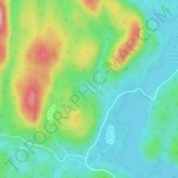
Name: Lac Rectangle topographic map, elevation, terrain.
Average elevation: 864 m
Minimum elevation: 810 m
Maximum elevation: 978 m
Thank you for supporting this site ❤️
Make a donation
Make a donation
Other topographic maps
Click on a map to view its topography, its elevation and its terrain.
Lac Jacques-Cartier
Canada > Québec > La Côte-de-Beaupré > Lac-Jacques-Cartier
Average elevation: 869 m
Thank you for supporting this site ❤️
Make a donation
Make a donation
Mont Raoul-Blanchard
Canada > Québec > La Côte-de-Beaupré > Lac-Jacques-Cartier
Average elevation: 982 m
Thank you for supporting this site ❤️
Make a donation
Make a donation
Rivière à l'Épaule
Canada > Québec > La Côte-de-Beaupré > Lac-Jacques-Cartier
Average elevation: 633 m
Étang des Perce-Neige
Canada > Québec > La Côte-de-Beaupré > Lac-Jacques-Cartier
Average elevation: 494 m