
Thank you for supporting this site ❤️
Make a donation
Make a donation
Moorcroft topographic map
Click on the map to display elevation.
Thank you for supporting this site ❤️
Make a donation
Make a donation
About this map
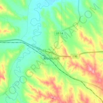
Name: Moorcroft topographic map, elevation, terrain.
Location: Moorcroft, Crook County, Wyoming, United States (44.25533 -104.97355 44.28389 -104.83845)
Average elevation: 1,301 m
Minimum elevation: 1,254 m
Maximum elevation: 1,393 m
Thank you for supporting this site ❤️
Make a donation
Make a donation
Other topographic maps
Click on a map to view its topography, its elevation and its terrain.