
Padrões topographic map
Interactive map
Click on the map to display elevation.
About this map
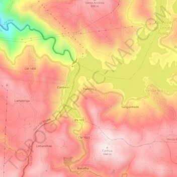
Name: Padrões topographic map, elevation, terrain.
Average elevation: 768 m
Minimum elevation: 371 m
Maximum elevation: 940 m
Other topographic maps
Click on a map to view its topography, its elevation and its terrain.
Garganta das Negras
Portugal > Vila Real > Montalegre > Outeiro
Garganta das Negras, Outeiro, Montalegre, Vila Real, Portugal
Average elevation: 1,346 m
Vilar de Perdizes
Portugal > Vila Real > Montalegre
Vilar de Perdizes, Montalegre, Vila Real, Portugal
Average elevation: 792 m
Ferral
Portugal > Vila Real > Montalegre
Ferral, Montalegre, Vila Real, 5470-122, Portugal
Average elevation: 614 m
Aldeia Nova do Barroso
Portugal > Vila Real > Montalegre > Chã
Aldeia Nova do Barroso, Chã, Montalegre, Vila Real, 5470-071, Portugal
Average elevation: 899 m
Pitões das Junias
Portugal > Vila Real > Montalegre
Pitões das Junias, Montalegre, Vila Real, 5470-370, Portugal
Average elevation: 1,159 m
Tourém
Portugal > Vila Real > Montalegre
Tourém, Montalegre, Vila Real, Portugal
Average elevation: 1,026 m