
Thank you for supporting this site ❤️
Make a donation
Make a donation
White Lake Grasslands Protected Area topographic map
Click on the map to display elevation.
Thank you for supporting this site ❤️
Make a donation
Make a donation
About this map
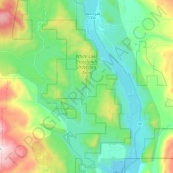
Name: White Lake Grasslands Protected Area topographic map, elevation, terrain.
Average elevation: 664 m
Minimum elevation: 305 m
Maximum elevation: 1,580 m
Thank you for supporting this site ❤️
Make a donation
Make a donation
Other topographic maps
Click on a map to view its topography, its elevation and its terrain.
Marron Valley
Canada > British Columbia > Regional District of Okanagan-Similkameen > Area I (Skaha West/Kaleden/Apex)
Average elevation: 772 m