
Elgin topographic map
Interactive map
Click on the map to display elevation.
About this map
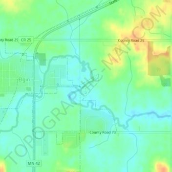
Name: Elgin topographic map, elevation, terrain.
Location: Elgin, Wabasha County, Minnesota, United States (44.12785 -92.23934 44.13047 -92.23555)
Average elevation: 329 m
Minimum elevation: 316 m
Maximum elevation: 353 m
Other topographic maps
Click on a map to view its topography, its elevation and its terrain.
Bellechester
United States > Minnesota > Wabasha County
Bellechester, Wabasha County, Minnesota, United States
Average elevation: 342 m
Lake City
United States > Minnesota > Wabasha County
Lake City, Wabasha County, Minnesota, 55041, United States
Average elevation: 230 m
Plainview
United States > Minnesota > Wabasha County > Plainview
Plainview, Wabasha County, Minnesota, 55964, United States
Average elevation: 348 m
Plainview
United States > Minnesota > Wabasha County > Plainview
Plainview, Wabasha County, Minnesota, 55964, United States
Average elevation: 348 m