
Hoheneck topographic map
Interactive map
Click on the map to display elevation.
About this map
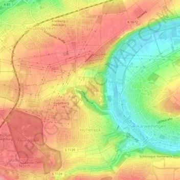
Name: Hoheneck topographic map, elevation, terrain.
Average elevation: 251 m
Minimum elevation: 195 m
Maximum elevation: 291 m
Other topographic maps
Click on a map to view its topography, its elevation and its terrain.
Am Sträßle
Deutschland > Baden-Württemberg > Landkreis Ludwigsburg > Ludwigsburg
Am Sträßle, Grünbühl, Grünbühl-Sonnenberg, Ludwigsburg, Landkreis Ludwigsburg, Baden-Württemberg, 71638, Deutschland
Average elevation: 293 m
Eglosheim
Deutschland > Baden-Württemberg > Landkreis Ludwigsburg > Ludwigsburg
Eglosheim, Ludwigsburg, Landkreis Ludwigsburg, Baden-Württemberg, 71634, Deutschland
Average elevation: 268 m