
Thank you for supporting this site ❤️
Make a donation
Make a donation
Gralhós topographic map
Click on the map to display elevation.
Thank you for supporting this site ❤️
Make a donation
Make a donation
About this map
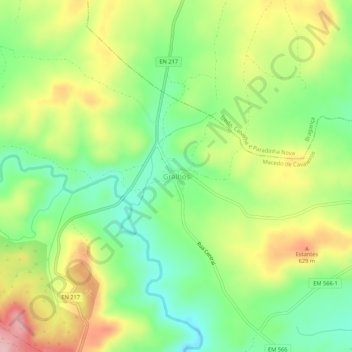
Name: Gralhós topographic map, elevation, terrain.
Average elevation: 564 m
Minimum elevation: 488 m
Maximum elevation: 665 m
Thank you for supporting this site ❤️
Make a donation
Make a donation
Other topographic maps
Click on a map to view its topography, its elevation and its terrain.
Ala e Vilarinho do Monte
Portugal > Distrito de Bragança > Macedo de Cavaleiros
Average elevation: 600 m
Thank you for supporting this site ❤️
Make a donation
Make a donation
Thank you for supporting this site ❤️
Make a donation
Make a donation
Thank you for supporting this site ❤️
Make a donation
Make a donation
Parque do Santuário de Santo Ambrósio
Portugal > Distrito de Bragança > Macedo de Cavaleiros > Vale da Porca
Average elevation: 573 m
Paisagem Protegida da Albufeira do Azibo
Portugal > Distrito de Bragança > Macedo de Cavaleiros
Average elevation: 634 m
Thank you for supporting this site ❤️
Make a donation
Make a donation