
Porth Navas topographic map
Interactive map
Click on the map to display elevation.
About this map
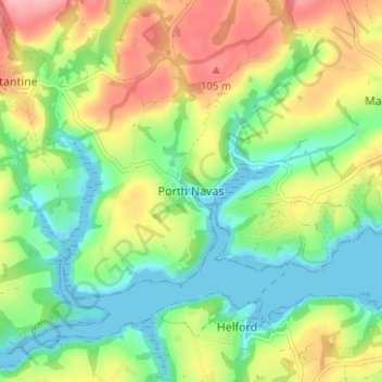
Name: Porth Navas topographic map, elevation, terrain.
Location: Porth Navas, Cornwall, England, TR11 5RJ, United Kingdom (50.08735 -5.16452 50.12735 -5.12452)
Average elevation: 46 m
Minimum elevation: 0 m
Maximum elevation: 115 m
Other topographic maps
Click on a map to view its topography, its elevation and its terrain.
St. John
United Kingdom > England > Cornwall
A few hundred metres north of St John village is an area of high ground called Vanderbands, the site of an Iron Age castle mentioned by John Norden (an English topographer who wrote a series of county histories) in his description of Cornwall published in 1728.
Average elevation: 53 m