
Thank you for supporting this site ❤️
Make a donation
Make a donation
Clavans-le-Haut topographic map
Click on the map to display elevation.
Thank you for supporting this site ❤️
Make a donation
Make a donation
About this map
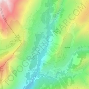
Name: Clavans-le-Haut topographic map, elevation, terrain.
Average elevation: 1,798 m
Minimum elevation: 1,221 m
Maximum elevation: 2,759 m
Thank you for supporting this site ❤️
Make a donation
Make a donation
Other topographic maps
Click on a map to view its topography, its elevation and its terrain.
Glacier des Quirlies
France > Auvergne-Rhône-Alpes > Isère > Clavans-en-Haut-Oisans
Average elevation: 2,979 m