
Pinios (Thessalia) topographic map
Interactive map
Click on the map to display elevation.
About this map
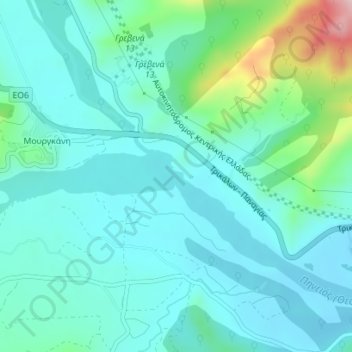
Name: Pinios (Thessalia) topographic map, elevation, terrain.
Average elevation: 288 m
Minimum elevation: 242 m
Maximum elevation: 486 m
Other topographic maps
Click on a map to view its topography, its elevation and its terrain.
Municipal Unit of Kheronia
Greece > Thessaly and Central Greece > Regional Unit of Boeotia
Average elevation: 224 m
Sergoula Beach
Greece > Thessaly and Central Greece > Regional Unit of Phocis > Municipal Unit of Efpalio > Κοινότητα Σεργούλας > Παραλία Σεργούλας
Average elevation: 69 m
Eratini
Greece > Thessaly and Central Greece > Regional Unit of Phocis > Municipal Unit of Tolofona
Average elevation: 46 m