
Thirimont topographic map
Interactive map
Click on the map to display elevation.
About this map
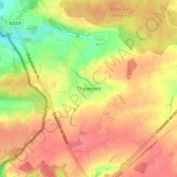
Name: Thirimont topographic map, elevation, terrain.
Location: Thirimont, Beaumont, Thuin, Henegouwen, Wallonië, 6500, België (50.24081 4.21644 50.28081 4.25644)
Average elevation: 205 m
Minimum elevation: 156 m
Maximum elevation: 236 m
Other topographic maps
Click on a map to view its topography, its elevation and its terrain.
Solre-Saint-Géry
België > Henegouwen > Thuin > Beaumont > Solre-Saint-Géry
Solre-Saint-Géry, Beaumont, Thuin, Henegouwen, Wallonië, 6500, België
Average elevation: 204 m