
Hawley Mountain topographic map
Interactive map
Click on the map to display elevation.
About this map
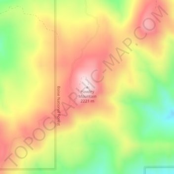
Name: Hawley Mountain topographic map, elevation, terrain.
Location: Hawley Mountain, Boise County, Idaho, United States (43.99234 -116.03100 43.99244 -116.03090)
Average elevation: 2,023 m
Minimum elevation: 1,789 m
Maximum elevation: 2,222 m
Other topographic maps
Click on a map to view its topography, its elevation and its terrain.
Placerville
United States > Idaho > Boise County
Placerville, Boise County, Idaho, 83666, United States
Average elevation: 1,343 m
Idaho City
United States > Idaho > Boise County
Idaho City, Boise County, Idaho, 83631, United States
Average elevation: 1,236 m
Horseshoe Bend
United States > Idaho > Boise County
Horseshoe Bend, Boise County, Idaho, United States
Average elevation: 867 m
North Raker
United States > Idaho > Boise County
North Raker, Boise County, Idaho, United States
Average elevation: 2,651 m
Garden Valley
United States > Idaho > Boise County
Garden Valley, Boise County, Idaho, 83622, United States
Average elevation: 1,004 m