
Thank you for supporting this site ❤️
Make a donation
Make a donation
Rawlins topographic map
Click on the map to display elevation.
Thank you for supporting this site ❤️
Make a donation
Make a donation
About this map
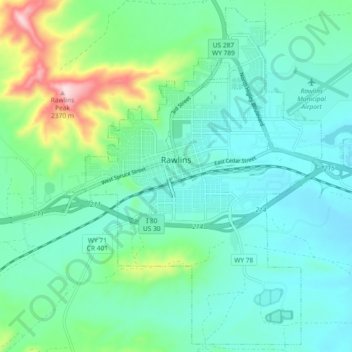
Name: Rawlins topographic map, elevation, terrain.
Location: Rawlins, Carbon County, Wyoming, United States (41.75472 -107.26851 41.82050 -107.17648)
Average elevation: 2,098 m
Minimum elevation: 2,023 m
Maximum elevation: 2,375 m
Thank you for supporting this site ❤️
Make a donation
Make a donation
Other topographic maps
Click on a map to view its topography, its elevation and its terrain.