
Portal topographic map
Interactive map
Click on the map to display elevation.
About this map
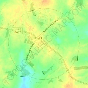
Name: Portal topographic map, elevation, terrain.
Location: Portal, Bulloch County, Georgia, United States (32.52541 -81.94322 32.54729 -81.91741)
Average elevation: 85 m
Minimum elevation: 67 m
Maximum elevation: 96 m
Other topographic maps
Click on a map to view its topography, its elevation and its terrain.
Lakeview Estates
United States > Georgia > Bulloch County > Statesboro
Lakeview Estates, Statesboro, Bulloch County, Georgia, 30459, United States
Average elevation: 65 m
Brians Chase
United States > Georgia > Bulloch County > Statesboro
Brians Chase, Statesboro, Bulloch County, Georgia, 30461, United States
Average elevation: 59 m
Register
United States > Georgia > Bulloch County
Register, Bulloch County, Georgia, United States
Average elevation: 57 m
Brooklet
United States > Georgia > Bulloch County
Brooklet, Bulloch County, Georgia, United States
Average elevation: 49 m
Statesboro
United States > Georgia > Bulloch County
Statesboro, Bulloch County, Georgia, United States
Average elevation: 66 m