
Batavia topographic map
Interactive map
Click on the map to display elevation.
About this map
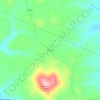
Name: Batavia topographic map, elevation, terrain.
Location: Batavia, Boone County, Arkansas, United States (36.23507 -93.24268 36.27507 -93.20268)
Average elevation: 455 m
Minimum elevation: 380 m
Maximum elevation: 618 m
Other topographic maps
Click on a map to view its topography, its elevation and its terrain.
Olvey
United States > Arkansas > Boone County
Olvey, Boone County, Arkansas, United States
Average elevation: 338 m
Omaha
United States > Arkansas > Boone County
Omaha, Boone County, Arkansas, 72662, United States
Average elevation: 390 m
Valley Springs
United States > Arkansas > Boone County
Valley Springs, Boone County, Arkansas, 72601, United States
Average elevation: 345 m
Diamond City
United States > Arkansas > Boone County
Diamond City, Boone County, Arkansas, 72630, United States
Average elevation: 223 m
Zinc
United States > Arkansas > Boone County
Zinc, Boone County, Arkansas, 72601, United States
Average elevation: 324 m
Bellefonte
United States > Arkansas > Boone County
Bellefonte, Boone County, Arkansas, 72601, United States
Average elevation: 340 m
South Lead Hill
United States > Arkansas > Boone County
South Lead Hill, Boone County, Arkansas, 72644, United States
Average elevation: 243 m
Bergman
United States > Arkansas > Boone County
Bergman, Boone County, Arkansas, 72601, United States
Average elevation: 384 m
Alpena
United States > Arkansas > Boone County
Alpena, Boone County, Arkansas, 72611, United States
Average elevation: 373 m
Capps
United States > Arkansas > Boone County
Capps, Boone County, Arkansas, United States
Average elevation: 434 m
Everton
United States > Arkansas > Boone County
Everton, Boone County, Arkansas, 72633, United States
Average elevation: 292 m
Lead Hill
United States > Arkansas > Boone County
Lead Hill, Boone County, Arkansas, United States
Average elevation: 306 m
Harrison
United States > Arkansas > Boone County
Harrison, Boone County, Arkansas, 72601, United States
Average elevation: 371 m