
Öschelbronn topographic map
Interactive map
Click on the map to display elevation.
About this map
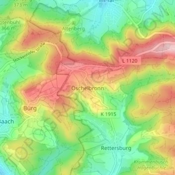
Name: Öschelbronn topographic map, elevation, terrain.
Average elevation: 373 m
Minimum elevation: 286 m
Maximum elevation: 487 m
Other topographic maps
Click on a map to view its topography, its elevation and its terrain.
Stöckenhof
Deutschland > Baden-Württemberg > Rems-Murr-Kreis > Berglen > Öschelbronn
Stöckenhof, Öschelbronn, Berglen, Rems-Murr-Kreis, Baden-Württemberg, 71573, Deutschland
Average elevation: 362 m