
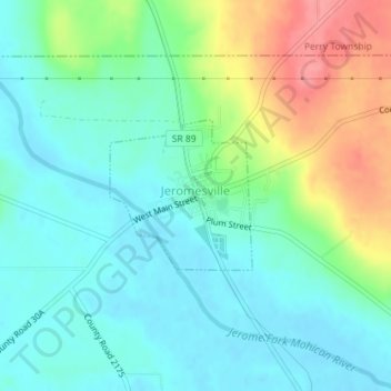
Jeromesville topographic map
Interactive map
Click on the map to display elevation.
About this map
Name: Jeromesville topographic map, elevation, terrain.
Average elevation: 316 m
Minimum elevation: 290 m
Maximum elevation: 377 m
Other topographic maps
Click on a map to view its topography, its elevation and its terrain.
Rowsburg
United States > Ohio > Ashland County
Rowsburg, Perry Township, Ashland County, Ohio, United States
Average elevation: 336 m
Ashland
United States > Ohio > Ashland County
Ashland, Ashland County, Ohio, United States
Average elevation: 341 m
Hayesville
United States > Ohio > Ashland County
Hayesville, Vermillion Township, Ashland County, Ohio, 44838, United States
Average elevation: 359 m
Cinnamon Lake
United States > Ohio > Ashland County
Cinnamon Lake, Jackson Township, Ashland County, Ohio, United States
Average elevation: 360 m
Perrysville
United States > Ohio > Ashland County
Perrysville, Green Township, Ashland County, Ohio, United States
Average elevation: 320 m
Sullivan
United States > Ohio > Ashland County
Sullivan, Sullivan Township, Ashland County, Ohio, 44880, United States
Average elevation: 347 m
Ruggles
United States > Ohio > Ashland County
Ruggles, Ruggles Township, Ashland County, Ohio, United States
Average elevation: 323 m
Nova
United States > Ohio > Ashland County
Nova, Troy Township, Ashland County, Ohio, 44859, United States
Average elevation: 345 m
Savannah
United States > Ohio > Ashland County
Savannah, Clear Creek Township, Ashland County, Ohio, 44874, United States
Average elevation: 327 m
Albion
United States > Ohio > Ashland County
Albion, Jackson Township, Ashland County, Ohio, 44287, United States
Average elevation: 352 m
Nankin
United States > Ohio > Ashland County
Nankin, Orange Township, Ashland County, Ohio, 44848, United States
Average elevation: 325 m
Bailey Lakes
United States > Ohio > Ashland County
Bailey Lakes, Clear Creek Township, Ashland County, Ohio, United States
Average elevation: 326 m
Vermillion Township
United States > Ohio > Ashland County
Vermillion Township, Ashland County, Ohio, 44838, United States
Average elevation: 369 m
Hanover Township
United States > Ohio > Ashland County
Hanover Township, Ashland County, Ohio, 44842, United States
Average elevation: 362 m
Mifflin
United States > Ohio > Ashland County
Mifflin, Mifflin Township, Ashland County, Ohio, United States
Average elevation: 337 m
Loudonville
United States > Ohio > Ashland County
Loudonville, Hanover Township, Ashland County, Ohio, 44842, United States
Average elevation: 328 m
Polk
United States > Ohio > Ashland County
Polk, Jackson Township, Ashland County, Ohio, United States
Average elevation: 379 m