
潮阳区 topographic map
Interactive map
Click on the map to display elevation.
About this map
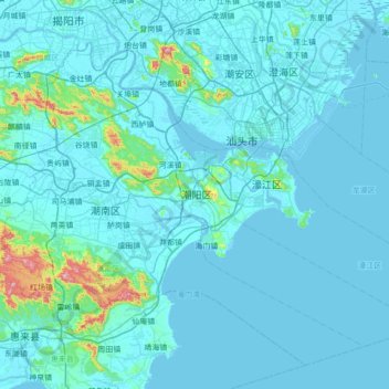
Name: 潮阳区 topographic map, elevation, terrain.
Location: 潮阳区, 汕头市, 广东省, 中国 (23.01823 116.31243 23.51569 117.00519)
Average elevation: 28 m
Minimum elevation: -3 m
Maximum elevation: 505 m
境内属沿海丘陵、平原地区。原潮阳市地形特征为“两山两江两平原”,地势自西北向东南倾斜。两山为大南山,小北山;两江为练江,榕江;两平原为练江平原与榕江平原。 今潮阳区地形特征为中部为小北山,小北山北边属榕江平原的一部分,小北山南部为练江平原一部分,东部为东山。练江出海口位于海门镇,沿海是带状沙滩地,分布于海门镇沿岸,经过多年营造的防护林培育,已成为固定或半固定沙土。
Other topographic maps
Click on a map to view its topography, its elevation and its terrain.