
Cave Spring topographic map
Interactive map
Click on the map to display elevation.
About this map
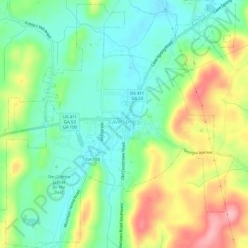
Name: Cave Spring topographic map, elevation, terrain.
Location: Cave Spring, Floyd County, Georgia, United States (34.08657 -85.36333 34.12769 -85.31400)
Average elevation: 237 m
Minimum elevation: 183 m
Maximum elevation: 331 m
Other topographic maps
Click on a map to view its topography, its elevation and its terrain.
Radio Springs
United States > Georgia > Floyd County
Radio Springs, Floyd County, Georgia, United States
Average elevation: 243 m
Lindale
United States > Georgia > Floyd County
Lindale, Floyd County, Georgia, 30147, United States
Average elevation: 229 m
Shannon
United States > Georgia > Floyd County
Shannon, Floyd County, Georgia, 30172, United States
Average elevation: 211 m
Rome
United States > Georgia > Floyd County
Rome, Floyd County, Georgia, United States
Average elevation: 211 m
Garden Lakes, City of Rome
United States > Georgia > Floyd County
Garden Lakes, City of Rome, Floyd County, Georgia, United States
Average elevation: 197 m
Berryhill
United States > Georgia > Floyd County > Rome
Berryhill, Rome, Floyd County, Georgia, 30165, United States
Average elevation: 207 m
Cave Spring
United States > Georgia > Floyd County > Cave Spring
Cave Spring, Floyd County, Georgia, 30124, United States
Average elevation: 235 m