
Thank you for supporting this site ❤️
Make a donation
Make a donation
Bastida topographic map
Click on the map to display elevation.
Thank you for supporting this site ❤️
Make a donation
Make a donation
About this map
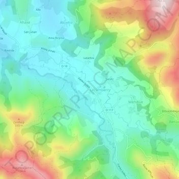
Name: Bastida topographic map, elevation, terrain.
Average elevation: 393 m
Minimum elevation: 212 m
Maximum elevation: 764 m
Thank you for supporting this site ❤️
Make a donation
Make a donation
Other topographic maps
Click on a map to view its topography, its elevation and its terrain.
Cromlechs d'Okabé
France > Nouvelle-Aquitaine > Pyrénées-Atlantiques > Lecumberry > Orgarate
Average elevation: 1,187 m