
Vlăhița topographic map
Interactive map
Click on the map to display elevation.
About this map
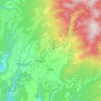
Name: Vlăhița topographic map, elevation, terrain.
Location: Vlăhița, Harghita, Romania (46.29923 25.45884 46.44361 25.63265)
Average elevation: 998 m
Minimum elevation: 585 m
Maximum elevation: 1,757 m
The town is situated between Odorheiu Secuiesc and Miercurea-Ciuc. Its 860 m (2,820 ft) altitude makes it the highest town in Harghita County.
Other topographic maps
Click on a map to view its topography, its elevation and its terrain.
Carpathian Mountains
Carpathian Mountains, Toplița, Harghita, 535705, Romania
Average elevation: 980 m
Izvoru Mureșului
Izvoru Mureșului, Voșlăbeni, Harghita, 537356, Romania
Average elevation: 887 m
Miercurea Ciuc
Romania > Harghita > Miercurea Ciuc
Miercurea Ciuc, Harghita, Romania
Average elevation: 689 m