
Brookfield Center topographic map
Interactive map
Click on the map to display elevation.
About this map
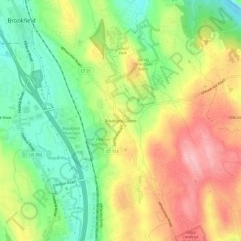
Name: Brookfield Center topographic map, elevation, terrain.
Average elevation: 133 m
Minimum elevation: 56 m
Maximum elevation: 221 m
Other topographic maps
Click on a map to view its topography, its elevation and its terrain.
Candlewood Shores
United States > Connecticut > Western Connecticut Planning Region > Brookfield
Candlewood Shores, Brookfield, Western Connecticut Planning Region, Connecticut, 06804, United States
Average elevation: 144 m
Candlewood Orchards
United States > Connecticut > Western Connecticut Planning Region > Brookfield
Candlewood Orchards, Brookfield, Western Connecticut Planning Region, Connecticut, 06804, United States
Average elevation: 141 m