
Thank you for supporting this site ❤️
Make a donation
Make a donation
Arefu topographic map
Click on the map to display elevation.
Thank you for supporting this site ❤️
Make a donation
Make a donation
About this map
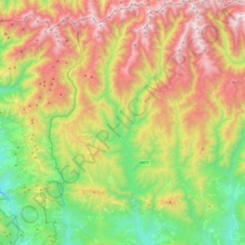
Name: Arefu topographic map, elevation, terrain.
Location: Arefu, Argeș, Romania (45.30273 24.51601 45.60837 24.74346)
Average elevation: 1,319 m
Minimum elevation: 482 m
Maximum elevation: 2,506 m
Thank you for supporting this site ❤️
Make a donation
Make a donation
Other topographic maps
Click on a map to view its topography, its elevation and its terrain.
Thank you for supporting this site ❤️
Make a donation
Make a donation
Thank you for supporting this site ❤️
Make a donation
Make a donation
Thank you for supporting this site ❤️
Make a donation
Make a donation
Thank you for supporting this site ❤️
Make a donation
Make a donation
Thank you for supporting this site ❤️
Make a donation
Make a donation
Negoiu
Negoiu Peak (Romanian: Vârful Negoiu pronounced [neˈɡoju]; Hungarian: Negoj-csúcs) is a mountain peak in the Făgăraș Mountains of the Southern Carpathians, located in Sibiu County, Romania, with an elevation of 2,535 m (8,317 ft). It is the second highest peak in Romania after the 2,544 m (8,346 ft)…
Average elevation: 2,059 m
Thank you for supporting this site ❤️
Make a donation
Make a donation
Thank you for supporting this site ❤️
Make a donation
Make a donation
Thank you for supporting this site ❤️
Make a donation
Make a donation
Thank you for supporting this site ❤️
Make a donation
Make a donation