
Schieder topographic map
Interactive map
Click on the map to display elevation.
About this map
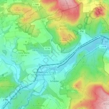
Name: Schieder topographic map, elevation, terrain.
Average elevation: 205 m
Minimum elevation: 110 m
Maximum elevation: 413 m
Other topographic maps
Click on a map to view its topography, its elevation and its terrain.
Wöbbel
Deutschland > Nordrhein-Westfalen > Kreis Lippe > Schieder-Schwalenberg
Wöbbel, Schieder-Schwalenberg, Kreis Lippe, Nordrhein-Westfalen, Deutschland
Average elevation: 161 m
Schiedersee
Deutschland > Nordrhein-Westfalen > Kreis Lippe > Schieder-Schwalenberg > Schieder > Freizeitzentrum SchiederSee
Schiedersee, Freizeitzentrum SchiederSee, Schieder, Schieder-Schwalenberg, Kreis Lippe, Nordrhein-Westfalen, 32816, Deutschland
Average elevation: 171 m