
Thank you for supporting this site ❤️
Make a donation
Make a donation
Puyricard topographic map
Click on the map to display elevation.
Thank you for supporting this site ❤️
Make a donation
Make a donation
About this map
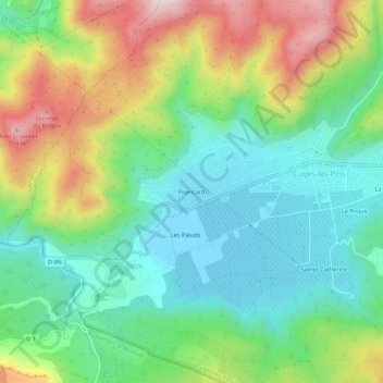
Name: Puyricard topographic map, elevation, terrain.
Average elevation: 313 m
Minimum elevation: 158 m
Maximum elevation: 603 m
Thank you for supporting this site ❤️
Make a donation
Make a donation
Other topographic maps
Click on a map to view its topography, its elevation and its terrain.
13780
France > Provence-Alpes-Côte d'Azur > Bouches-du-Rhône > Cuges-les-Pins
Average elevation: 514 m