
Engenthal topographic map
Interactive map
Click on the map to display elevation.
About this map
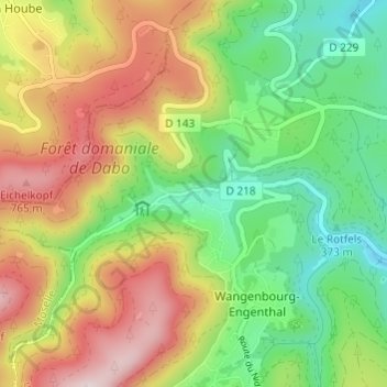
Name: Engenthal topographic map, elevation, terrain.
Average elevation: 530 m
Minimum elevation: 317 m
Maximum elevation: 816 m
Other topographic maps
Click on a map to view its topography, its elevation and its terrain.
Freudeneck
France > Grand Est > Bas-Rhin > Wangenbourg-Engenthal
Freudeneck, Wangenbourg-Engenthal, Molsheim, Bas-Rhin, Grand Est, France métropolitaine, 67710, France
Average elevation: 415 m
Windsbourg
France > Grand Est > Bas-Rhin > Wangenbourg-Engenthal
Windsbourg, Wangenbourg-Engenthal, Molsheim, Bas-Rhin, Grand Est, France métropolitaine, 67710, France
Average elevation: 744 m
Obersteigen
France > Grand Est > Bas-Rhin > Wangenbourg-Engenthal
Obersteigen, Wangenbourg-Engenthal, Molsheim, Bas-Rhin, Grand Est, France métropolitaine, 67710, France
Average elevation: 472 m
Wolfsthal
France > Grand Est > Bas-Rhin > Wangenbourg-Engenthal
Wolfsthal, Wangenbourg-Engenthal, Molsheim, Bas-Rhin, Grand Est, France métropolitaine, 67710, France
Average elevation: 633 m