
Malonty topographic map
Interactive map
Click on the map to display elevation.
About this map
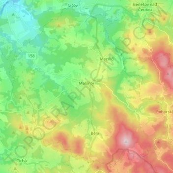
Name: Malonty topographic map, elevation, terrain.
Average elevation: 695 m
Minimum elevation: 535 m
Maximum elevation: 961 m
Other topographic maps
Click on a map to view its topography, its elevation and its terrain.
Historic Centre of Český Krumlov
Czechia > Southwest > South Bohemian Region > Český Krumlov
Average elevation: 542 m