
Monsanto topographic map
Interactive map
Click on the map to display elevation.
About this map
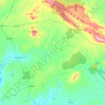
Name: Monsanto topographic map, elevation, terrain.
Average elevation: 412 m
Minimum elevation: 249 m
Maximum elevation: 809 m
Other topographic maps
Click on a map to view its topography, its elevation and its terrain.
Idanha-a-Velha
Portugal > Centro > União de Freguesias de Monsanto e Idanha-a-Velha
Idanha-a-Velha, União de Freguesias de Monsanto e Idanha-a-Velha, Idanha-a-Nova, Castelo Branco, Beira Interior Sul, Centro, Portugal
Average elevation: 343 m