
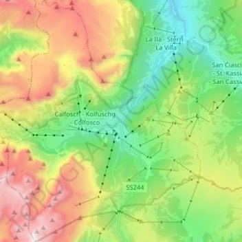
Corvara in Badia - Corvara topographic map
Interactive map
Click on the map to display elevation.
About this map
Name: Corvara in Badia - Corvara topographic map, elevation, terrain.
Average elevation: 2,037 m
Minimum elevation: 1,355 m
Maximum elevation: 3,125 m
Other topographic maps
Click on a map to view its topography, its elevation and its terrain.
Graun im Vinschgau - Curon Venosta
Italy > Trentino – Alto Adige/Südtirol > South Tyrol > Graun - Curon Venosta
Average elevation: 1,794 m
Costadedoi
Italy > Trentino – Alto Adige/Südtirol > South Tyrol > San Ćiascian - St. Kassian - San Cassiano
Average elevation: 1,712 m
Maring
Italy > Trentino – Alto Adige/Südtirol > South Tyrol > La Ila - Stern - La Villa
Average elevation: 1,727 m
Welsberg - Monguelfo
Italy > Trentino – Alto Adige/Südtirol > South Tyrol > Welsberg-Taisten - Monguelfo-Tesido
Average elevation: 1,289 m
Villa Nöia
Italy > Trentino – Alto Adige/Südtirol > South Tyrol > La Ila - Stern - La Villa
Average elevation: 1,632 m
Funtanacia
Italy > Trentino – Alto Adige/Südtirol > South Tyrol > La Ila - Stern - La Villa
Average elevation: 1,787 m
Schneespitz - Cima della Neve
Italy > Trentino – Alto Adige/Südtirol > South Tyrol > Predoi
Average elevation: 2,497 m
Roen
Italy > Trentino – Alto Adige/Südtirol > South Tyrol > Tramin an der Weinstraße - Termeno sulla Strada del Vino
Average elevation: 1,740 m
Pinzon - Pinzano
Italy > Trentino – Alto Adige/Südtirol > South Tyrol > Montan an der Weinstraße - Montagna sulla Strada del Vino
Average elevation: 524 m
Grube - Fossa
Italy > Trentino – Alto Adige/Südtirol > South Tyrol > Oberradein - Redagno di Sopra
Average elevation: 1,477 m
Atzwang - Campodazzo
Italy > Trentino – Alto Adige/Südtirol > South Tyrol > Ritten - Renon
Average elevation: 786 m
St. Anton - Sant'Antonio
Italy > Trentino – Alto Adige/Südtirol > South Tyrol > St. Nikolaus - San Nicolò
Average elevation: 745 m
Ortler - Ortles
Italy > Trentino – Alto Adige/Südtirol > South Tyrol > Stilfs - Stelvio
The Ortler was first climbed by Josef Pichler [de] ("Pseirer-Josele"), a chamois hunter from St. Leonhard in Passeier, and his companions Johann Leitner and Johann Klausner from Zell am Ziller on 27 September 1804. The ascent had been a request of Archduke Johann of Austria, who felt strongly that after the…
Average elevation: 3,175 m
Sulden - Solda
Italy > Trentino – Alto Adige/Südtirol > South Tyrol > Stilfs - Stelvio
Average elevation: 2,232 m
St. Georg - San Giorgio di Eores
Italy > Trentino – Alto Adige/Südtirol > South Tyrol > Brixen - Bressanone
Average elevation: 1,476 m
Turnerkamp - Cima di Campo
Italy > Trentino – Alto Adige/Südtirol > South Tyrol > Mühlwald - Selva dei Molini
Average elevation: 2,868 m
St. Anton - Sant'Antonio
Italy > Trentino – Alto Adige/Südtirol > South Tyrol > St. Nikolaus - San Nicolò
Average elevation: 745 m
Langtauferer Tal - Vallelunga
Italy > Trentino – Alto Adige/Südtirol > South Tyrol > Graun - Curon Venosta
Average elevation: 2,513 m
Hoher Weißzint - Punta Bianca
Italy > Trentino – Alto Adige/Südtirol > South Tyrol > Mühlwald - Selva dei Molini
Average elevation: 2,905 m
Antermëia - Untermoi - Antermoia
Italy > Trentino – Alto Adige/Südtirol > South Tyrol > San Martin de Tor - San Martino in Badia - St. Martin in Thurn
Average elevation: 1,677 m
Schluderbach - Carbonin
Italy > Trentino – Alto Adige/Südtirol > South Tyrol > Toblach - Dobbiaco
Average elevation: 1,776 m
Lengmoos - Longomoso
Italy > Trentino – Alto Adige/Südtirol > South Tyrol > Ritten - Renon > Klobenstein - Collalbo
Average elevation: 1,049 m
Siebeneich - Settequerce
Italy > Trentino – Alto Adige/Südtirol > South Tyrol
Average elevation: 427 m
Tierseralpl - Alpe di Tires
Italy > Trentino – Alto Adige/Südtirol > South Tyrol > Tiers - Tires
Average elevation: 2,285 m
Dörfl
Italy > Trentino – Alto Adige/Südtirol > South Tyrol > Gsies - Valle di Casies > St. Magdalena - Santa Maddalena in Casies
Average elevation: 1,770 m
Sulden - Solda
Italy > Trentino – Alto Adige/Südtirol > South Tyrol > Stilfs - Stelvio
Average elevation: 2,232 m
Weissenbach - Rio Bianco
Italy > Trentino – Alto Adige/Südtirol > South Tyrol > Sarntal - Sarentino
Average elevation: 1,718 m
Saslonch - Langkofel - Sassolungo
Italy > Trentino – Alto Adige/Südtirol > South Tyrol > Sëlva - Wolkenstein - Selva di Val Gardena
Average elevation: 2,320 m
Calfosch - Kolfuschg - Colfosco
Italy > Trentino – Alto Adige/Südtirol > South Tyrol
Average elevation: 1,931 m
Gherdëina - Grödnertal - Val Gardena
Italy > Trentino – Alto Adige/Südtirol > South Tyrol > Urtijëi - St. Ulrich in Gröden - Ortisei
Average elevation: 1,588 m