
Siriwo River topographic map
Interactive map
Click on the map to display elevation.
About this map
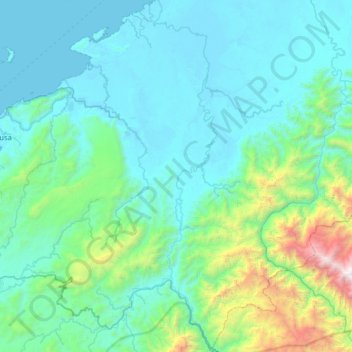
Name: Siriwo River topographic map, elevation, terrain.
Average elevation: 411 m
Minimum elevation: -1 m
Maximum elevation: 3,271 m
Other topographic maps
Click on a map to view its topography, its elevation and its terrain.
Nabire
Indonesia > Central Papua > Kabupaten Nabire
Nabire, Kabupaten Nabire, Central Papua, Western New Guinea, 98811, Indonesia
Average elevation: 100 m