
Loveland topographic map
Interactive map
Click on the map to display elevation.
About this map
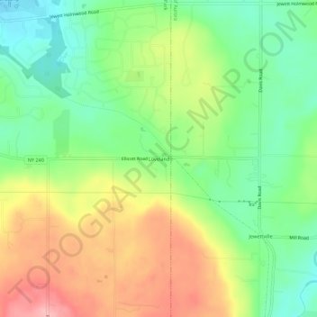
Name: Loveland topographic map, elevation, terrain.
Average elevation: 325 m
Minimum elevation: 267 m
Maximum elevation: 402 m
Other topographic maps
Click on a map to view its topography, its elevation and its terrain.
Webster Corners
United States > New York > Erie County > Town of Orchard Park
Webster Corners, Town of Orchard Park, Erie County, New York, 14127, United States
Average elevation: 244 m
Windom
United States > New York > Erie County > Town of Orchard Park
Windom, Town of Orchard Park, Erie County, New York, 14219, United States
Average elevation: 217 m
Ellicott
United States > New York > Erie County > Town of Orchard Park
Ellicott, Town of Orchard Park, Erie County, New York, 14127, United States
Average elevation: 309 m
Duells Corner
United States > New York > Erie County > Town of Orchard Park
Duells Corner, Town of Orchard Park, Erie County, New York, 14127, United States
Average elevation: 271 m