
Hogansburg topographic map
Interactive map
Click on the map to display elevation.
About this map
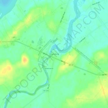
Name: Hogansburg topographic map, elevation, terrain.
Average elevation: 55 m
Minimum elevation: 44 m
Maximum elevation: 71 m
Other topographic maps
Click on a map to view its topography, its elevation and its terrain.
Akwesasne
United States > New York > Franklin County > Town of Bombay
Akwesasne, Town of Bombay, Franklin County, New York, United States
Average elevation: 57 m
South Bombay
United States > New York > Franklin County > Town of Bombay
South Bombay, Town of Bombay, Franklin County, New York, 12957, United States
Average elevation: 83 m