
Sagehorn topographic map
Interactive map
Click on the map to display elevation.
About this map
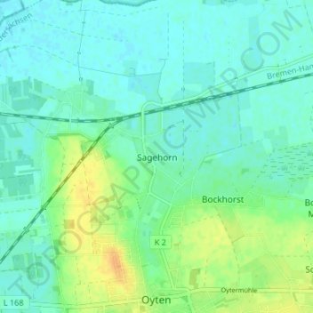
Name: Sagehorn topographic map, elevation, terrain.
Average elevation: 10 m
Minimum elevation: 2 m
Maximum elevation: 28 m
Other topographic maps
Click on a map to view its topography, its elevation and its terrain.
Bockhorst
Deutschland > Niedersachsen > Landkreis Verden > Oyten
Bockhorst, Oyten, Landkreis Verden, Niedersachsen, 28876, Deutschland
Average elevation: 13 m
Schaphusen
Deutschland > Niedersachsen > Landkreis Verden > Oyten
Schaphusen, Oyten, Landkreis Verden, Niedersachsen, 28876, Deutschland
Average elevation: 15 m