
Thank you for supporting this site ❤️
Make a donation
Make a donation
Burton topographic map
Click on the map to display elevation.
Thank you for supporting this site ❤️
Make a donation
Make a donation
About this map
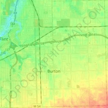
Name: Burton topographic map, elevation, terrain.
Location: Burton, Genesee County, Michigan, United States (42.95958 -83.69282 43.04820 -83.57375)
Average elevation: 237 m
Minimum elevation: 215 m
Maximum elevation: 265 m
Thank you for supporting this site ❤️
Make a donation
Make a donation
Other topographic maps
Click on a map to view its topography, its elevation and its terrain.
Genessee County Recreational Area
United States > Michigan > Genesee County > Genesee Charter Township
Average elevation: 231 m