
Ward 38 topographic map
Interactive map
Click on the map to display elevation.
About this map
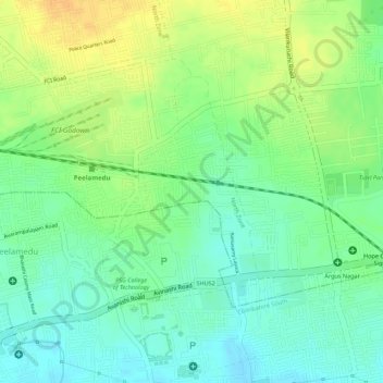
Name: Ward 38 topographic map, elevation, terrain.
Average elevation: 415 m
Minimum elevation: 400 m
Maximum elevation: 432 m
Other topographic maps
Click on a map to view its topography, its elevation and its terrain.
Noyyal River
India > Tamil Nadu > Coimbatore
Noyyal River, Coimbatore, Coimbatore district, Tamil Nadu, 641001, India
Average elevation: 463 m
Singanallur Lake
India > Tamil Nadu > Coimbatore
Singanallur Lake, ESI Dispensary, Ward 63, East Zone, Coimbatore, Coimbatore district, Tamil Nadu, 641001, India
Average elevation: 390 m
Kurichi Kulam
India > Tamil Nadu > Coimbatore > Podanur
Kurichi Kulam, Palghat road, Ward 87, South Zone, Podanur, Coimbatore South, Coimbatore district, Tamil Nadu, 641008, India
Average elevation: 406 m
Thudiyalur
India > Tamil Nadu > Coimbatore
Thudiyalur, Ward 1, North Zone, Coimbatore, Coimbatore North, Coimbatore District, Tamil Nadu, 641001, India
Average elevation: 454 m
Ward 10
India > Tamil Nadu > Coimbatore
Ward 10, West Zone, Coimbatore, Coimbatore district, Tamil Nadu, 641001, India
Average elevation: 436 m
Ward 35
India > Tamil Nadu > Coimbatore
Ward 35, East Zone, Coimbatore, Coimbatore district, Tamil Nadu, 641001, India
Average elevation: 394 m
Ward 13
India > Tamil Nadu > Coimbatore
Ward 13, West Zone, Coimbatore, Coimbatore district, Tamil Nadu, 641001, India
Average elevation: 440 m