
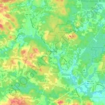
Fremont topographic map
Interactive map
Click on the map to display elevation.
About this map
Name: Fremont topographic map, elevation, terrain.
Average elevation: 58 m
Minimum elevation: 34 m
Maximum elevation: 97 m
On August 10, 1959, a Boeing B-52 Stratofortress crashed in Fremont. The aircraft, serial number 54-2682, had departed Westover Air Force Base in Chicopee, Massachusetts. During flight at 34,000 feet (10,000 m), the crew heard several loud bangs, the radar system became inoperative, and the plane began to vibrate. As the vibrations became more severe, the plane began to lose altitude, and the pilot ordered the crew to bail out at 14,000 feet (4,300 m). The pilot remained with the aircraft for several additional minutes, then ejected. The plane crashed into Spruce Swamp at 2:50 p.m. local time. The pilot and seven crew members all survived. The crash was attributed to a failure of the radome on the nose of the aircraft.
Other topographic maps
Click on a map to view its topography, its elevation and its terrain.
East Kingston
United States > New Hampshire > Rockingham County
East Kingston, Rockingham County, New Hampshire, United States
Average elevation: 38 m
Providence Hill
United States > New Hampshire > Rockingham County > Atkinson
Providence Hill, Atkinson, Rockingham County, New Hampshire, 03811, United States
Average elevation: 72 m
Hampstead
United States > New Hampshire > Rockingham County
Hampstead, Rockingham County, New Hampshire, United States
Average elevation: 81 m
Auburn
United States > New Hampshire > Rockingham County
Auburn, Rockingham County, New Hampshire, 03032, United States
Average elevation: 107 m
Epping
United States > New Hampshire > Rockingham County
Epping, Rockingham County, New Hampshire, 03042, United States
Average elevation: 55 m
North Danville
United States > New Hampshire > Rockingham County > Danville
North Danville, Danville, Rockingham County, New Hampshire, 03819, United States
Average elevation: 62 m
Peppermint Corner
United States > New Hampshire > Rockingham County > Derry
Peppermint Corner, Derry, Rockingham County, New Hampshire, 03038, United States
Average elevation: 94 m
Salem Depot
United States > New Hampshire > Rockingham County > Salem > Salem Depot
Salem Depot, Salem, Rockingham County, New Hampshire, 03079, United States
Average elevation: 50 m
Rye
United States > New Hampshire > Rockingham County
Rye, Rockingham County, New Hampshire, United States
Average elevation: 9 m
Rye Beach Village District
United States > New Hampshire > Rockingham County > Rye Beach Village District
Rye Beach Village District, Rye, Rockingham County, New Hampshire, 03871, United States
Average elevation: 7 m
Newmarket
United States > New Hampshire > Rockingham County > Newmarket
Newmarket, Rockingham County, New Hampshire, 03857, United States
Average elevation: 21 m
Kensington
United States > New Hampshire > Rockingham County
Kensington, Rockingham County, New Hampshire, United States
Average elevation: 32 m
Windham
United States > New Hampshire > Rockingham County
Windham, Rockingham County, New Hampshire, 03087, United States
Average elevation: 81 m
Collettes Grove
United States > New Hampshire > Rockingham County > Derry
Collettes Grove, Derry, Rockingham County, New Hampshire, 03841, United States
Average elevation: 79 m
Kingston
United States > New Hampshire > Rockingham County
Kingston, Rockingham County, New Hampshire, United States
Average elevation: 45 m
North Hampton
United States > New Hampshire > Rockingham County > North Hampton
North Hampton, Rockingham County, New Hampshire, 03862, United States
Average elevation: 18 m
Salem
United States > New Hampshire > Rockingham County
Salem, Rockingham County, New Hampshire, 03079, United States
Average elevation: 60 m
Londonderry
United States > New Hampshire > Rockingham County > Londonderry
Londonderry, Rockingham County, New Hampshire, 03053, United States
Average elevation: 91 m
Newington
United States > New Hampshire > Rockingham County
Newington, Rockingham County, New Hampshire, United States
Average elevation: 10 m
Stratham
United States > New Hampshire > Rockingham County
Stratham, Rockingham County, New Hampshire, 03885, United States
Average elevation: 22 m
South Hampton
United States > New Hampshire > Rockingham County
South Hampton, Rockingham County, New Hampshire, United States
Average elevation: 38 m
Exeter
United States > New Hampshire > Rockingham County
Exeter, Rockingham County, New Hampshire, United States
Average elevation: 24 m
Hampton
United States > New Hampshire > Rockingham County
Hampton, Rockingham County, New Hampshire, 03842, United States
Average elevation: 11 m
The Sands
United States > New Hampshire > Rockingham County > Seabrook
The Sands, Seabrook, Rockingham County, New Hampshire, 03874, United States
Average elevation: 1 m