
Dutchtown topographic map
Interactive map
Click on the map to display elevation.
About this map
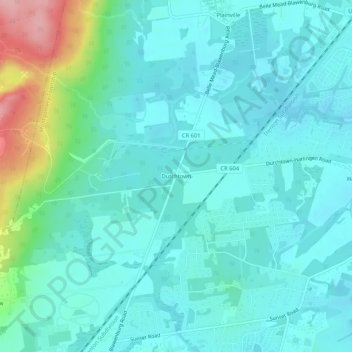
Name: Dutchtown topographic map, elevation, terrain.
Average elevation: 49 m
Minimum elevation: 21 m
Maximum elevation: 171 m
Other topographic maps
Click on a map to view its topography, its elevation and its terrain.
Skillman
United States > New Jersey > Somerset County > Montgomery Township
Skillman, Montgomery Township, Somerset County, New Jersey, 08558, United States
Average elevation: 56 m