
Straß topographic map
Interactive map
Click on the map to display elevation.
About this map
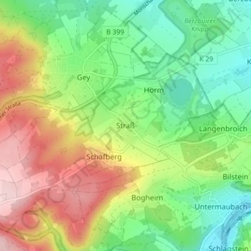
Name: Straß topographic map, elevation, terrain.
Average elevation: 252 m
Minimum elevation: 153 m
Maximum elevation: 401 m
Other topographic maps
Click on a map to view its topography, its elevation and its terrain.
Vossenack
Deutschland > Nordrhein-Westfalen > Kreis Düren > Hürtgenwald > Vossenack
Vossenack, Hürtgenwald, Kreis Düren, Nordrhein-Westfalen, 52393, Deutschland
Average elevation: 380 m