
PURBALINGGA topographic map
Interactive map
Click on the map to display elevation.
About this map
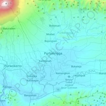
Name: PURBALINGGA topographic map, elevation, terrain.
Average elevation: 284 m
Minimum elevation: 11 m
Maximum elevation: 3,403 m
Other topographic maps
Click on a map to view its topography, its elevation and its terrain.
Karangsentul
Indonesia > Central Java > Purbalingga
Karangsentul, Purbalingga, Central Java, Java, 53372, Indonesia
Average elevation: 82 m
RT 04 RW 1
Indonesia > Central Java > Purbalingga > RT 04 RW 1
RT 04 RW 1, Dusun Pejagan II, Purbalingga, Central Java, Indonesia
Average elevation: 1,213 m
Bobotsari
Indonesia > Central Java > Purbalingga > Bobotsari
Bobotsari, Purbalingga, Central Java, 53353, Indonesia
Average elevation: 182 m